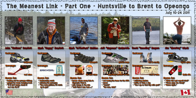
Scott Rogers is the first member of the "Six On Six" group to get a trip report on-line. And what a report it is! Well-written, full of great pictures and humour, it definitely does not gloss over the challenges of the trip. Make yourself a couple of pots of tea for this one, because with a 15-day trip, it is no surprise that he created a 15-page report:
smedleyco.com/Algonquin-Park/Trip-Logs/Meanest-Link-Part-One
Quick ice update:
And while I'm here, here is a little snow and ice update: rain and mild weather has definitely made a BIG dent in the Algonquin Park snowpack. Having said that, I must report that people are still cross-country skiing and snowshoeing this week in very "spring skiing" conditions. All lakes are frozen right up to the shore, small streams are in flood, and the long-range forecast is looking colder by the end of next. So, shall we see a repeat of the record-breaking 2010 ice-out? I doubt it. Early-ish maybe, but not that early.
Cast your vote for ice-out predictions in Algonquin Park:
Canoe Lake Ice-Out Contest:
http://canoelake.ca/
New! AO's own Lake Opeongo ice-out contest, with absolutely no prizes except bragging rights. It's a really long URL, simply click here.
The great silver bird took a picture yesterday which shows a large patch of open water in the East Arm of Opie. Much grey ice as well. It won't be long.
ReplyDeleteGood eye, Anonymous. Jerry and I checked the image and agree with you on the grey ice but disagree on the open water. Check your map, that "patch" is Opeongo Island, looking dark and snow-free. People were snowmobiling on Oxtongue Lake yesterday, and people who work regularly in the park estimate that there is probably a foot of ice on most lakes. Lakes in Huntsville area are looking very black, they could go soon. Algonquin Park lakes typically go out two to three weeks after that. This is far from "typical" weather, so who knows!
ReplyDeleteFor any people wondering about Anonymous' "Great Silver Bird" reference, check this link, referenced many times before on this blog:
ReplyDeletehttp://coastwatch.glerl.noaa.gov/modis/modis.cgi/modis?region=g&page=1
For the record, we did report on a big hole in Opeongo back in April of 2009. This appeared just north of Bates Island but was hard to see from the satellite image:
http://algonquinoutfitters.blogspot.ca/2009/04/big-hole-spotted-in-opeongo-lake.html